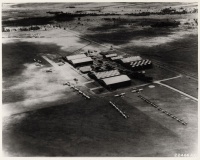
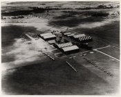
Clark Field, hangars (aerial), no. 1 (4.14.1211)
From The BenHaven Archives
| Clark Field, hangars (aerial), no. 1 | |
|---|---|
 Page 1 | |
| Original Location | |
| Place | |
| Latitude/ Longitude |
|
| Physical Characteristics | |
| Pages | 2 |
| Photocopy/reproduction | No |
| Dimensions | 10 in. x 8 in., image is 9.5 in. x 7.4375 in. |
| Sources | |
| Creator/Origin | Unknown |
| Donor | Charles E. Montgomery |
| Collection | Unincorporated |
| Date | 1 January 1939 - 31 December 1939 |
| Categorizations | |
Clark Field, hangars (aerial), no. 1 (BenHaven archives reference no.: 4.14.1211) Aerial photograph of the hangar area at Clark Field.
Provenance
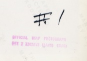
This photograph, found in the papers of Alfred R. Young, may have come from Charles E. Montgomery. The following text is stamped on the back of the print: Official USAF Photograph [D]ET 7 1363AVS (AAVS) (MAC)" The original is part of the Alfred R. Young papers in The BenHaven Archives.
This document is Artifact 4.14.1211 in the BenHaven Archives.
Artifact scans
Notes
Related Artifacts
External Links
Categories:
- Pages where expansion depth is exceeded
- Artifact
- Clark Field
- Fort Stotsenburg
- Pampanga
- Luzon
- Philippines
- Original Documents, Images, and Artifacts
- Artifacts with unknown origins
- Artifacts donated by Charles E. Montgomery
- Unincorporated into a collection
- Photos
- Aerial Photos
- Official USAF Photos
- 1939 Artifacts
- January 1939 Artifacts
- 1 January 1939 Artifacts
- December 1939 Artifacts
- 31 December 1939 Artifacts
- Artifacts requiring review
- Aircraft Hangar

