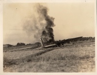
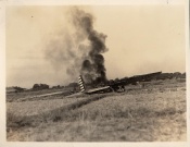
Nichols Field, B10 crash, no. 2 (4.14.1270)
From The BenHaven Archives
| Nichols Field, B10 crash, no. 2 | |
|---|---|
 Page 1 | |
| Original Location | |
| Place | |
| Latitude/ Longitude |
|
| Physical Characteristics | |
| Pages | 1 |
| Photocopy/reproduction | No |
| Dimensions | 4.8125 in. x 3.75 in., image is 4.5625 in. x 3.4375 in. |
| Sources | |
| Creator/Origin | Unknown |
| Donor | Raymond A. Patenaude |
| Collection | Unincorporated |
| Date | 1 January 1938 - 31 December 1938 |
| Categorizations | |
Nichols Field, B10 crash, no. 2 (BenHaven archives reference no.: 4.14.1270) A B10 crash. Perhaps the same as the crash scene in photograph 4.14.0291.
Provenance
Raymond A. Patenaude sent this photograph to Alfred R. Young in 1996. The original print and accompanying correspondence are part of the Alfred R. Young papers in The BenHaven Archives.
This document is Artifact 4.14.1270 in the BenHaven Archives.
Artifact scans
Notes
Related Artifacts
External Links
Categories:
- Pages where expansion depth is exceeded
- Artifact
- Nichols Field
- Manila
- Luzon
- Philippines
- Original Documents, Images, and Artifacts
- Artifacts with unknown origins
- Artifacts donated by Raymond A. Patenaude
- Unincorporated into a collection
- Photos
- 1938 Artifacts
- January 1938 Artifacts
- 1 January 1938 Artifacts
- December 1938 Artifacts
- 31 December 1938 Artifacts
- Artifacts requiring review
- B10
- Bomber Aircraft
- Aircraft
- Aircraft Wreckage
